Pan-Artic Summary
Status and Disclaimer
A request was sent to the contributors of the 2009 SEARCH Sea Ice Outlook to summarize the 2009 arctic sea ice season. A key question was: were there systematic or physical changes that contributed to a greater observed sea ice extent this year or was it within the range of natural variability? We appreciate all participants and reviewers who contributed their time to making the 2009 Outlook effort a success for the second year.
The Sea Ice Outlook provides a forum for researchers to evaluate their understanding of the state of arctic sea ice and for the community to jointly assess a range of factors that contribute to arctic summer sea ice minima. The Sea Ice Outlook is not a formal consensus forecast or prediction for arctic sea ice extent, nor is it intended as a replacement for existing efforts or centers with operational responsibility. Additional background material about the Outlook effort can be found on the background page.
Summary
The arctic summer sea ice extent minimum in September 2009 (5.36 million square kilometers) was greater than that observed in 2007 or 2008, but still much less than the 1979–2000 mean value (7.1 million square kilometers), based on NSIDC September mean estimates. The 2009 observed extent is approaching the 30-year linear trend line of previous September minima (5.5 million square kilometers). All Outlook projection values for September 2009 were less than the observed value, with a median projection of 4.6 million square kilometers and a range of 4.2-5.2 million square kilometers based on June data. While sea ice extent at the beginning of July and weather conditions in June and July were largely conducive to a new sea ice extent minimum, weather in August and September was unfavorable. In fall of 2009, the area of second-year sea ice has increased relative to 2007 and 2008. However, the arctic ice pack remains substantially younger, thinner, and more mobile than prior to 2005. The long-term trend in summer sea ice extent is still downward. Furthermore, the rate of refreezing at the end of October is less than in 2007.
2009 Minimum Sea Ice Extent
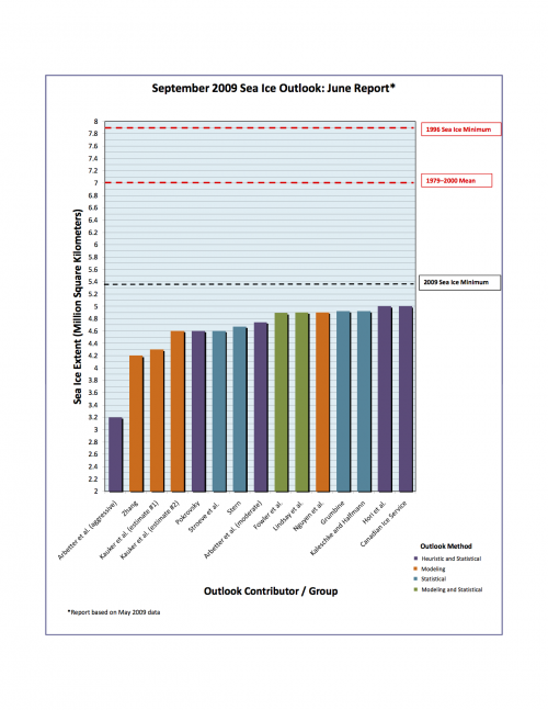
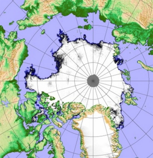
The projections of the Sea Ice Outlook groups for the September 2009 mean minimum ice extent had a median value of 4.7 million square kilometers based on May data and 4.6 million square kilometers based on June data with a range of 4.2-5.2 million square kilometers (Figure 1). These estimates are below the observed value of 5.36 million square kilometers as provided by Walt Meier, NSIDC. Figure 2a and 2b show the spatial extent of mid-September sea ice for 2008 and 2009.
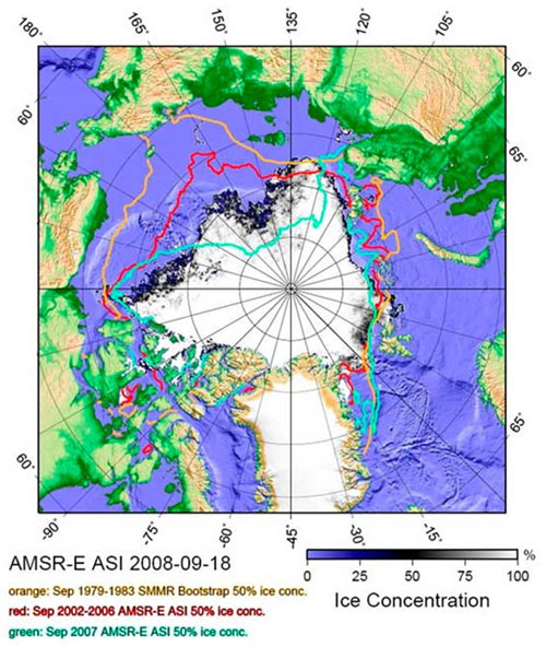
(Site: http://www.ifm.uni-hamburg.de/)
Comparison of 2009 with 2007, 2008, and earlier years will require further analysis. A major question is whether large one-year changes in extent such as the decline from 2006 to 2007 or the increase from 2008 to 2009 are simply a result of natural variability or whether they indicate systemic changes leading to an acceleration or deceleration in the decline. The vast areas of open water in 2007 and 2008 increased the amount of summer ocean heat storage. At the start of fall freeze-up, sea ice continues to be thinner and more mobile than prior to 2005, which might cause the decline in extent to persist or accelerate. Considerable first-year sea ice survived summer melt in 2009 to constitute second-year sea ice, in contrast with low survival in other recent years. Further, it only took one month of persistent wind conditions to slow the rate of sea ice loss, resulting in an increase in 2009 sea ice extent compared to 2007 and 2008.
Another way of stating the question is whether below normal multi-year ice fractions account for a persistence in ice extent anomalies on interannual time scales, or whether the ice pack is now back in a mode with no interannual correlation between extent anomalies (Bitz, personal communication). Lindsay comments, “with nonstationary statistics, the standard error of the fit over past years is not a good measure of the uncertainty in the prediction.”
With regard to the 2009 outlook projections relative to the observed value, Kaleschke states that the projections are at the upper range of the uncertainty based on statistical methods and Kauker finds that the observed extent is within the error tolerance based on model hindcast estimates. For example, seven of the twenty ensemble members from the Alfred Wegener Institute modeling group gave Outlook estimates above 5.0 million square kilometers. He adds that their group believes that the likelihood of '2007 events' is higher now than a decade before and that this is connected to the gradually reduced sea ice thickness.
The range of Outlook projections in 2009 was narrower than in 2008. The estimates in 2008 covered a range of plausible scenarios driven by physical processes that could favor a return to previous conditions or a continued loss of all first-year sea ice. Neither extreme was observed. 2009 Outlook contributions suggest a focus on persistent conditions and extent values relative to 2008. The 2009 Outlook results point out the importance of a more thorough exploration of approaches that can help establish a probabilistic range of September sea ice conditions. Difficulties are mentioned by Lindsay.
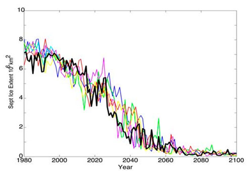
One potential analog for the future evolution of the arctic ice pack comes from the work of Holland, Bitz and Tremblay (2006), based on the September extent from a seven-member ensemble of the Community Climate System Model Version 3 (CCSM3, Figure 3). If one examines the ensemble member shown in black in Figure 3, periods of stagnation in ice decline as long as ten years can be discerned between major ice loss events. Is 2009 simply part of such an extended pause, as it will take another near-perfect synchrony of summer weather conditions to provide another major drop in sea ice extent (Overland)? Or does the background trend in Figure 3 represent the global warming “forced” signal of an ever-increasing sea ice loss, plus natural variability (Bitz)? Or are these two interpretations of the same thing? The data from 2007-2009 suggest further lively discussions on the future of the Arctic at meetings during the coming year.
Summer 2009 Sea Ice and Meteorological Conditions
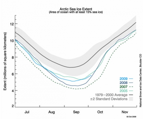
Different seasonal progressions of summer sea ice loss are apparent in daily time series of sea ice extent from different years (Figure 4). In the summer of 2009, sea ice was more extensive at the beginning of July than in 2007 and less extensive than in 2008. The rate of loss was greater in July 2009 than in 2007. As with 2005, the sea ice extent minimum remains below the 2-standard deviation mark based on the years 1979–2000.
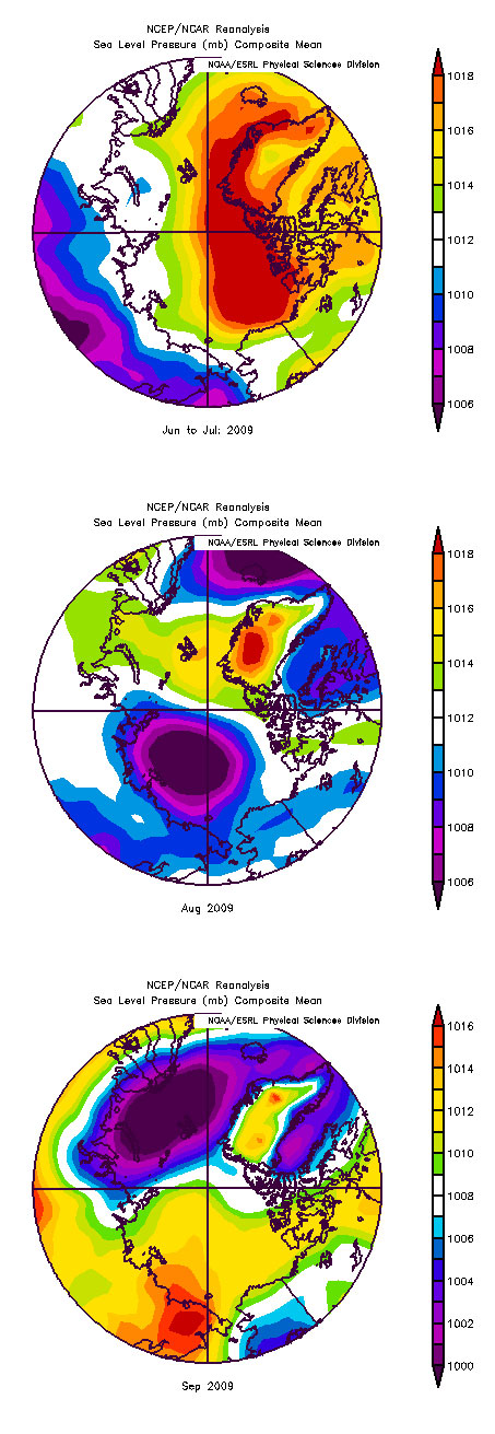
With regard to summer meteorological forcing, June and July of 2009 were dominated by a strong Arctic Dipole climate pattern in sea level pressure (SLP) similar to 2007, with high pressure over the Beaufort Sea and winds blowing from the Bering Strait across the North Pole, promoting both advection of warm air and compaction of the ice pack (Figure. 5). Unlike 2007, however, August and September 2009 SLP patterns were not conducive to continued sea ice loss.
The regional progression of the early stages of the melt season can have a substantial impact on ice evolution later in the summer. Anomalies in ice albedo or downwelling shortwave radiation at the start of the melt season have more than a five-fold larger impact on solar heating of ice than those at the end of the melt season (Perovich et al., J. Geophys. Res., 2007, doi:10.1029/2006JC003558). As evident from contributions for the regional outlook, above normal cloudiness resulted in delayed ice break-up and sluggish melt in the Western and Central Arctic. The contribution by Hori illustrates how above normal cloudiness in particular in the later stages of summer was set up by the same atmospheric circulation pattern that impacted ice extent in other ways as well.
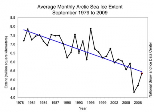
The long-term time series of sea ice extent and trend since 1979, as plotted by NSIDC, is shown in Figure 6. While the value for 2009 is near the trend line (see Stern), arctic sea ice internal conditions are considerably different from 2005. There has been a major reduction in multi-year sea ice (~35 %) since 2004 (Kwok et al., 2009).
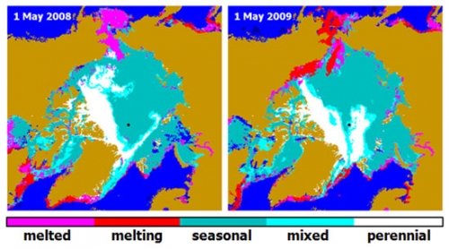
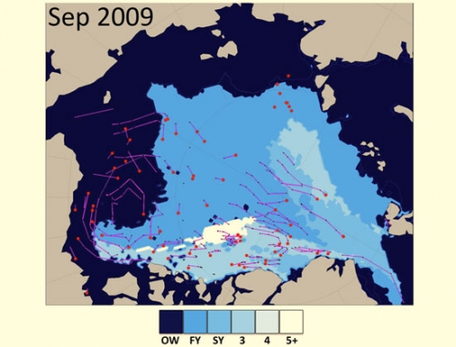
The amount of perennial sea ice in May 2009 was similar to May 2008 (Figure 7). The tongue of perennial sea ice between the North Pole and Eurasia is the sea ice that survived the summer of 2008. Over the winter and spring 2009, this feature became smaller as some of the sea ice was entrained in the Transpolar Drift Stream and exported into the Greenland Sea (Kwok, personal communication). Since the forcing along the Transpolar Drift was not consistently strong in summer 2009, this region of the perennial ice pack mostly remained in place (Nghiem, personal communication), as confirmed by the adverse August/September weather patterns shown in Figure 5. Based on sea ice age calculations, much of this sea ice tongue remained in the Arctic Ocean basin to become second-year sea ice (as discussed on the NSIDC web site by Fowler and Maslanik; and by Ignatius Rigor as Figure 8 below). In situ observations from Barber suggest that satellite products may in fact be overestimating the amount of multi-year sea ice in the southeastern Beaufort Sea. An arctic ice pack that consists mostly of first- and second-year rather than multi-year sea ice, implies a thinner, more mobile ice cover relative to conditions five or more years ago.
Lessons Learned From the 2009 Outlook
September 2009 sea ice extent was driven by preexisting sea ice conditions at the end of spring, as well as variable wind patterns over the course of summer. 2007 remains as an anomalous year dominated by steady meteorological conditions during the entire summer. In 2009, August and September wind patterns were not conducive to major sea ice loss.
The fact that all 2009 Outlook projections were below the observed September 2009 value is of concern. However, when projection uncertainty is taken into account, as well as it can be, the observed value is within an expected range of values. Of concern is the convergence of the Outlook projections into a narrow range.
The last point emphasizes the need for further development and analysis of probabilistic forecast ranges and measures of uncertainty, critical to future efforts.
2009 signals that it could be several more years, in a probabilistic sense, before conditions favor another major sea ice loss event. However, the increase in sea ice extent for 2009 does not exceed past interannual variability in a near-continuous, 30-year downward trend in summer sea ice extent.
Melt-out of sea ice near the North Pole continues to be more exceptional than in the Beaufort and Siberian sectors because of the decreasing importance of solar forcing. This may be a limiting factor in the rate of future sea ice loss.
Consideration of multiple sources of data, including visual observations, is important for reducing uncertainty in the Outlooks. Buoys provide key observations for mapping and attributing summer ice loss: drift, bottom vs. top melt, amount of snow accumulation, nature of ponds (even if anecdotal from web cams), and thickness of level ice. Considerable effort should be made to estimate thickness distributions of ice and snow cover needed to initialize simulations. Aircraft and other reconnaissance are also helpful.
Because of the importance of initial conditions for the sea ice state, more work is needed on remote sensing retrieval and interpretation of spring and summer ice concentrations and ice conditions, even if the present operational algorithms are not changed.
Both full sea ice models and seasonal melt projections applied to detailed sea ice distributions and trajectories provided the main semi-quantitative information for the Outlook.
Update: 28 October 2009
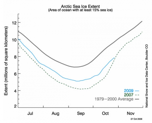
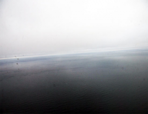
This slowing of the rate of freeze up is consistent with observations from a USCG C130 sea ice reconnaissance flight made on 30 September to the Beaufort Sea. Large areas had open water with no indication of grease ice formation, implying considerable ocean heat storage.
Summaries of Statements Provided by Outlook Participants on the Summer 2009 Sea Ice Season:
Full Contributions can be accessed at the bottom of this report.
Arbetter, et al.: The National Ice Center (NIC) Conservative Outlook values for June and July were close to the NSIDC reported minimum of 5.36 million kilometers squared, while the August value fell away. The NIC reported value was 5.0 million kilometers squared . Since the outlook was explicitly linked to the amount of multi-year ice in the basin, the drop in the August value is not surprising; all ice types are decreased in that month. Nevertheless, the results this year are encouraging. Given a relatively simple method, we were able to come within 2.5% of the NSIDC value. Within the Outlook project, there may be differences in how each group obtains their area (e.g., model grid cells of varying resolution, sea ice charts, and satellite observations); each of these could produce a different value for ice extent. When considering the success and accuracy of a given method, it is important to take into account whether and how the area of ice extent value is obtained and if this value is significantly different than the NSIDC value.
Barber et al.: In situ observations from Canadian Research Icebreaker (NGCC) Amundsen indicate that the multi-year sea ice pack in the Southern Beaufort Sea was not as ubiquitous as it appeared within satellite remote sensing data products in early September 2009. A large sector of what was remotely sensed to be multi-year sea ice at 7 to 9+ tenths ice cover, consisting primarily of multy-year ice floes, was in fact a surface of heavily decayed ice composed of some small multi-year floes (1 tenth) interspersed in a cover dominated by heavily decayed first-year floes (1 tenths) and overlain by new sea ice in areas of negative freeboard and in open water between floes.
Hori et al.: In June and July it seemed that a sea level pressure pattern similar to 2007 was appearing over the Arctic Ocean. It was cloudy over Bering Strait and the East Siberian Sea (and maybe over Barrow). Atmospheric pressure patterns had drastically changed in August. Low pressure persisted over the Arctic Ocean and it was mostly cloudy there. Wind pattern seems unfavorable for ice reduction.
Kaleschke and Halfmann: Our first guess was 4.92 +/-0.43 million square kilometers and was not updated through the season. The actual September extent lies just at the upper range of the uncertainty. It should be mentioned that 2009 lies below the linear extrapolation of the decreasing long term trend. It is difficult to judge if a linear or a quadratic model better fits the observed trend.
Kauker et al.: We think that the observed extent is within the error tolerance. We assume that the atmosphere will stay most likely close to the atmosphere in the years 1989 to 2008. This gives us a mean value and a range of possible values. Even for the August outlook the range was pretty large. The atmosphere of 1996 gives a value of about 5.9 million square kilometers and the 2007 atmosphere a value of about 4.1 million square kilometers. However, we believe that the likelihood of '2007 events' is much higher now than a decade before and this is connected to the gradually reduced sea ice thickness.
Lindsay: In retrospect, the mean thickness was the best predictor from almost all months, particularly early in the season, but the error standard deviation of the prediction equation using mean thickness in past years was larger than that for the area of sea ice less than 1.0 m predictor. Perhaps a more problematic issue is that the statistical relationships between elements of the system are changing rapidly. Until a new stable regime is established and we can get an adequate number of sample years of this new regime, statistical methods of prediction will be limited in their accuracy. With nonstationary statistics the standard error of the fit over past years is not a good measure of the uncertainty in the prediction.
Lukovich and Barber: The results from an investigation of stratospheric circulation in winter and spring, and comparison of summertime surface winds and SLP with vortex splitting and minima in sea ice extent composites suggested that the September, 2009 ice extent would be comparable to or less than the September ice extent minimum in 2008, based on dynamic considerations.
Meier et al.: NSIDC's outlook of 4.6 million square kilometers was based on survival rates of first-year ice. This year, we attempted to account for a lower rate of first-year ice loss near the pole, but our outlook was still significantly lower than the actual minimum. This was due to slower early season melt due to increased cloudiness, relatively cooler temperatures, and winds during August and September that were not conducive to ice loss. These factors helped to retain a greater than normal amount of first-year ice resulting in the higher-than-predicted minimum extent. At the end of the melt season, there was a considerable area of low-concentration (and likely relatively thin) sea ice near the ice edge, particularly in the northern Beaufort/Chukchi Seas. A slightly warmer summer and/or more favorable winds at the end of the season would have resulted in a final minimum extent more in line with the predicted value. * This represents the complete contribution from Meier et al.
Morison and Untersteiner: We expected the ice to recover from 2008 to 2009 a similar amount to the recovery from 2007 to 2008 plus a little for the added factors of little snow, late melt, and some cooler water. Complex systems are capable of flipping off the deep end, but they prefer not to. After the extreme 2007 minimum, the ice cover has shown to be capable of a slight recovery, despite the anomalous heat storage in the ocean at the end of summer. The ice export through Fram Strait has shown no significant trend during the past 30 years (Kwok, Spreen et al., and others). Snow cover appeared light and temperatures were very cold during the spring 2009 North Pole Environmental Observatory (NPEO) buoy deployment. The NPEO met buoy and web camera buoy indicated that snow and ice melt was delayed until about July 10th, two weeks later than usual.
Nguyen et al.: Initial sensitivity experiments showed that near-surface air temperature and specific humidity fields already contain a significant amount of information about the sea ice coverage. As a consequence, any sea ice coverage ensemble forecast that uses the 2007 temperature and specific humidity fields as part of the input surface BCs will approximately have the 2007 sea ice minimum as the lower end estimate of the ensemble. In addition, a combination of thinner sea ice initial conditions [Kwok and Rothrock 2009] and high surface temperature would significantly reduce arctic sea ice coverage. This is the main reason for our lower than observed sea ice extent prediction.
Stern: My estimate for September average sea ice extent (4.67 million square kilometers) was simply based on extrapolation of the 10-year trend (1989-2008). It turns out that extrapolation of the 30-year trend (1979–2008, 5.46 million square kilometers) would have been very close to the observed extent of 5.36 million square kilometers. Sea ice extents in September 2007 and 2008 were well below the long-term trend. The apparent acceleration turns out to have been just a couple of anomalously low years. Those low years were due in part to the loss of older sea ice, which was replaced by younger (hence thinner) ice that was more susceptible to summer melt. It's important to note that the trend in summer sea ice extent is still downward, even if 2009 had more ice than 2007 and 2008.
Zhang: With the starting date of prediction being July 1st, the area of the predicted ice extent is smaller than that of the observed but the shape of the predicted ice extent is close to that of the observed. Thus the prediction is perhaps within the error tolerance in many areas, but not in other areas. The model has the tendency to under-predict September ice extent because the SAT over a large area in the Arctic Ocean is higher than the recent (2002–2008) climate during January through June. This may explain why many of the participating groups also underestimate the September ice extent when the ice conditions during January through June were heavily taken into account. When the ice conditions in spring are used as an indicator of what may happen several months later in September, there is a need to significantly raise the error bar considering the significant variability of weather and climate.
| Attachment | Size |
|---|---|
| Download All Individual 2009 Pan-Arctic Summary Report Contributions (PDF - 4.3 MB)4.3 MB | 4.3 MB |
| Attachment | Size |
|---|---|
| Arbetter11.94 KB | 11.94 KB |
| Barber et al.1.6 MB | 1.6 MB |
| Hori et al.744.22 KB | 744.22 KB |
| Kaleschke and Halfmann77.15 KB | 77.15 KB |
| Kauker et al.942.85 KB | 942.85 KB |
| Lindsay et al.68.3 KB | 68.3 KB |
| Lukovich and Barber508.05 KB | 508.05 KB |
| Morison and Untersteiner60.87 KB | 60.87 KB |
| Nguyen et al.892.26 KB | 892.26 KB |
| Stern40.23 KB | 40.23 KB |
| Zhang274.8 KB | 274.8 KB |
| Attachment | Size |
|---|---|
| Barber et al.1.6 MB | 1.6 MB |
| Eicken et al.190.36 KB | 190.36 KB |
| Gudmandsen140.26 KB | 140.26 KB |
| Gudmandsen and Kwok506.39 KB | 506.39 KB |
| Howell and Duguay433.89 KB | 433.89 KB |
| Pokrovsky29.42 KB | 29.42 KB |
| Zhang324.87 KB | 324.87 KB |


