Assessment of Current Ice Conditions Relevant to Distribution and Access of Walrus
Due to unforeseen circumstances, we were not able to update the SIWO forecast on Friday, 10 June. We apologize and will post an update next week.
However, please see the updated satellite images and ice condition update below for recent information on ice distribution.
Observations and Comments
Observations of Sea Ice Development
9 June 2011 - Hajo Eicken; researcher, University of Alaska Fairbanks
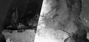
The radar satellite image (Envisat, courtesy of Polarview) shows break-up of shorefast ice along the coastline from Wales past Shishmaref into Kotzebue Sound (see also update from Curtis Nayokpuk June 10).
In the western part of the region, ice has already cleared along the coast, creating a corridor of open water, toward the east (and near Shishmaref) it is only opening up now and expected to clear out further in the coming days, if favorable winds persist.
There are still large ice floes and streamers of ice offshore that likely carry walrus and bearded seal (see C. Nayokpuk's comments).
Envisat, courtesy of Polarview

8 June 2011 - Update on ice conditions in Anadyr Gulf, Igor Krupnik (Smithsonian Institution), Gary Hufford, Hajo Eicken
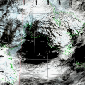
Ice from the Gulf of Anadyr (Anadyr River and in the Kresta Bay) traditionally shows later on at Gambell, about 1-3 weeks after the main Bering Sea ice is gone. However, this year, early break-up in this region (several weeks compared to historical break-up dates in mid-June to mid-July) likely means that very little if any sea ice can be expected from this area to pass by Gambell in the coming days or weeks.
The break-up sequence for the Gulf of Anadyr is visible in the two satellite images, the first showing stretches of landfast ice in the west on May 29, but a near-ice free bay in the north (Kresta Bay). The second image (June 3) shows much of this ice cleared out.


Radar satellite images showed a few remnant streamers of ice north of St Lawrence Island early in the week, but these are gone by June 8 as well.
